
Home › Master Knowledge Gateway
HimState Digital Reference Layer
Encyclopedia of Himachal Pradesh
The central reference architecture for the Western Himalayan state: documenting administrative history, physiography, river basins, cultural heritage, and district-level geographies through verified public records.
Edition 2026 • Official Administrative, Census & Survey Data • Interconnected Reference Framework
55,673 km²
Geographical Area
12
Administrative Districts
68,64,602
Population (2011 Census)
82.80%
Literacy Rate(2011 Census)
25 Jan 1971
Statehood Day
Overview · State Framework · Knowledge Pillars · Districts Directory · Geography & Rivers · Official Repositories · Reference FAQs
The Institutional Index
The Master Digital Reference for Himachal Pradesh
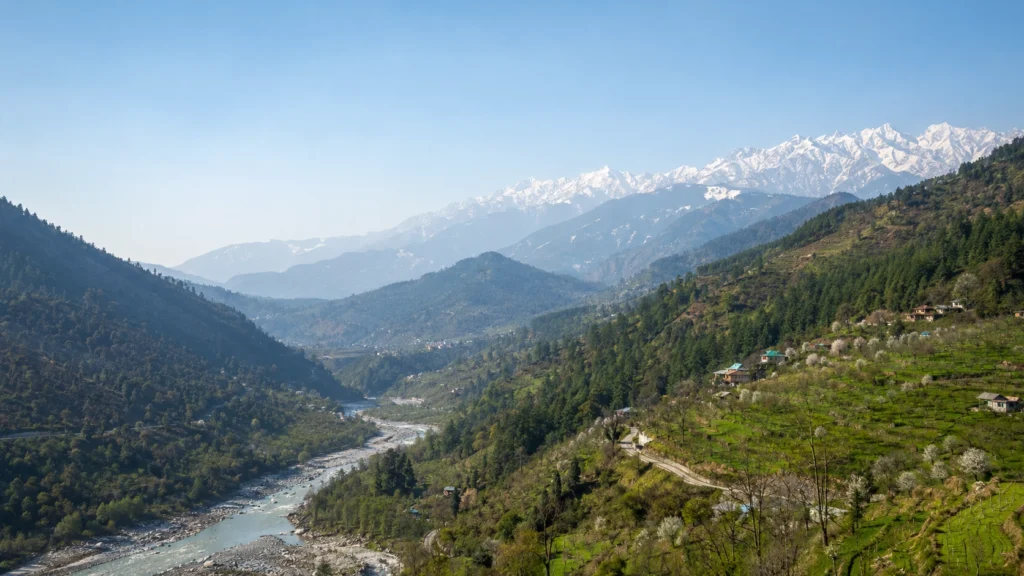
Himachal Pradesh is a mountainous state situated in the Western Himalayas, bordered by Jammu & Kashmir and Ladakh to the north, Punjab to the west, Haryana to the southwest, Uttarakhand to the southeast, and the Tibet Autonomous Region to the east.
Administering 55,673 square kilometres across complex elevations ranging from 350 metres in the southern Shivalik foothills to over 6,800 metres in the Great Himalayan and Zanskar ranges, the state represents an uncommon intersection of micro-climates, ethnic traditions, hydro-geological significance, and public sector-led human development.
The Encyclopedia of Himachal Pradesh serves as the master navigation layer of HimState.in. It organises verified data across administrative, economic, physical, and historical disciplines, bridging macro-level overviews with deeply researched monographs, gazetteers, and district guides.
Encyclopedia Roles
- Navigate 6 interconnected pillar hubs.
- Access all 12 district reference dossiers.
- Track historical integration from 1948 to statehood in 1971.
- Review verified hydrological and demographic metrics.
- Cross-reference official government databases and gazetteers.
Core State Profile
Administrative & Geographic Baseline
Fundamental structural data verified through the Census of India, Ministry of Home Affairs, and the Department of Economics & Statistics.
Capitals
Shimla & Dharamshala
Shimla serves as the Summer/Primary Capital; Dharamshala was officially designated as the Winter Capital in 2017.
GOVERNMENT AND POLITICS
How Himachal Pradesh Is Governed
Explore Himachal Pradesh’s government, Vidhan Sabha, ministers, elected representatives and administrative system.
Judiciary
High Court of HP
Seated at Shimla, established in 1971 following the State of Himachal Pradesh Act, 1970.
State Symbols
Snow Leopard & Jujurana
Animal: Snow Leopard; Bird: Western Tragopan (Jujurana); Tree: Deodar Cedar; Flower: Pink Rhododendron.
Systematic Structure
Core Knowledge Pillars
Access dedicated master hubs categorised by academic and administrative discipline.
Pillar 01 · Macroeconomics
Economy & Development
GSDP metrics, the apple value chain, Baddi-Barotiwala-Nalagarh industrial corridors, 27,400+ MW hydro allocations, and fiscal deficit analysis.
Pillar 02 · Heritage
Culture, Faith & Heritage
Kath-Kuni architecture, the indigenous devta governance system, Western Himalayan dialects, GI crafts (Chamba Rumal, Kullu Shawl), and festivals.
Pillar 03 · Public Administration
Governance & Welfare Schemes
State administrative apparatus, Him Unnati Yojana, Mukhya Mantri Swavlamban Yojna, environmental guidelines, and official gazette tracking.
Pillar 04 · Physical Environment
Geography & River Basins
Physiographic zones (Shivalik to Zanskar), the 5 primary river systems (Chenab, Ravi, Beas, Satluj, Yamuna), glaciers, seismic fault lines, and mountain passes.
Pillar 05 · Livelihoods & Transit
Tourism & Alpine Trails
Sustainable homestay regulations, high-altitude alpine circuits, national park conservation zones (GHNP, Pin Valley), and pilgrim trails.
Pillar 06 · Political Evolution
History & Statehood Formation
Trigarta and Kuluta janapadas, the 30 princely hill states, the Praja Mandal struggles, the Suket Satyagraha (1948), and the 1966 Punjab Reorganisation Act.
Administrative Geography
The 12 Administrative Districts
Each district represents a distinct ecological zone, socio-economic structure, and historical evolution.
Chamba
6,528 km² · Headquarters: Chamba · Ancient Ravi valley kingdom, Pangi-Bharmour tribal belts, Kath-Kuni & wood carving heritage.
Kangra
5,739 km² · Headquarters: Dharamshala · Most populous district; seat of Trigarta rulers, Kangra miniature art, and Kangra tea gardens.
Mandi
3,950 km² · Headquarters: Mandi · Choti Kashi with 81 historic stone temples; major agricultural valleys (Balh) and Beas basin hydro assets.
[LINK NEEDED: district-mandi]
Kullu
5,503 km² · Headquarters: Kullu · Valley of the Gods (Kuluta), international Dusshera festival, Great Himalayan National Park (UNESCO).
[LINK NEEDED: district-kullu]
Shimla
5,131 km² · Headquarters: Shimla · Former British summer capital; commercial apple production core (Rohru, Jubbal, Kotgarh), Kalka-Shimla Railway.
[LINK NEEDED: district-shimla]
Lahaul & Spiti
13,841 km² · Headquarters: Keylong · Largest district by area (~24.8% of state); high-altitude cold desert, Tibetan Buddhist monasteries (Ki, Tabo).
[LINK NEEDED: district-lahaul-spiti]
Kinnaur
6,401 km² · Headquarters: Reckong Peo · High-grade late-harvest apples, Satluj river gorge, Kinner Kailash circuit, Indo-Tibetan border culture.
[LINK NEEDED: district-kinnaur]
Solan
1,936 km² · Headquarters: Solan · Mushroom City, Baddi-Barotiwala-Nalagarh (BBN) pharmaceutical corridor, Dr. YS Parmar Horticulture University.
[LINK NEEDED: district-solan]
Sirmaur
2,825 km² · Headquarters: Nahan · Giri river basin, Renuka Ji sacred lake, Paonta Sahib Sikh pilgrimage, Kala Amb industrial estate.
[LINK NEEDED: district-sirmaur]
Bilaspur
1,167 km² · Headquarters: Bilaspur · Gobind Sagar reservoir, Bhakra Dam headworks, AIIMS Bilaspur, Naina Devi shrine, cement manufacturing.
[LINK NEEDED: district-bilaspur]
Hamirpur
1,118 km² · Headquarters: Hamirpur · Highest literacy rate (88.15%) and population density (407/km²); NIT Hamirpur, Baba Balak Nath temple.
[LINK NEEDED: district-hamirpur]
Una
1,540 km² · Headquarters: Una · Gateway lowland district bordering Punjab; Swan river basin, broad-gauge railway head, Chintpurni Shaktipeeth.
[LINK NEEDED: district-una]
Physical Environment
Physiography & Major River Basins
The topography transitions across three distinct longitudinal mountain zones from south to north.
Outer Himalayas (Shivaliks)
Elevation: 350 m to 1,500 m
Covers the southern belts of Kangra, Hamirpur, Bilaspur, Una, and lower Solan/Sirmaur. Known historically as ‘Manak Parbat’. Features sub-tropical climate, pine forests, and broad longitudinal valleys (Duns) such as Paonta and Nalagarh.
Lesser Himalayas (Central Belt)
Elevation: 1,500 m to 4,500 m
Characterised by dramatic mountain ranges: the Dhauladhar (the ‘White Range’) through Kangra and Mandi, and the Pir Panjal through Chamba and upper Kullu. Hosts major temperate fruit orchards, deodar forests, and major population centers.
Great Himalayas & Zanskar
Elevation: 4,500 m to 6,800+ m
Northern alpine zone separating Himachal from Tibet. Comprises Kinnaur, Spiti, and the upper reaches of Pangi. Cold arid desert conditions, high passes (Rohtang, Kunzum, Baralacha La), and prominent glacial systems.
The Five Major River Systems
Himachal Pradesh feeds both the Indus and Gangetic drainage basins, serving as India’s premier high-altitude freshwater catchment.
Satluj (Shatadru)
Origin: Rakshastal (Tibet) · Enters at Shipki La · Longest river in HP · Feeds Bhakra Dam.
Beas (Vipasha)
Origin: Beas Kund (Rohtang) · Traverses Kullu, Mandi, Kangra · Feeds Pong Dam reservoir.
Chenab (Chandrabhaga)
Confluence of Chandra & Bhaga at Tandi · Largest in terms of water volume discharge.
Ravi (Iravati)
Origin: Bara Bhangal (Kangra) · Drains Chamba valley between Dhauladhar & Pir Panjal.
Yamuna
Easternmost river · Traces border with Uttarakhand · Fed by major tributaries: Tons, Giri, Pabbar.
Institutional Records
Official Gazettes & Primary Data Archives
Direct access to state administrative records, census abstracts, and official statistical publications.
e-Gazette of HP
Official notifications, legislative acts, and executive orders published by the Department of Printing & Stationery.
Economics & Statistics
Annual Economic Surveys, Statistical Year Books, and block-level socio-economic profiles.
Vidhan Sabha Archives
Legislative Assembly debates, committee reports, and state constitutional documentation.
HP State Archives
Historical records of princely hill states, British residency correspondence, and colonial records.
Frequently Asked Questions
Reference Inquiries
When did Himachal Pradesh become a full state of India?
Himachal Pradesh was initially formed as a Chief Commissioner’s Province on 15 April 1948 by merging 30 princely hill states. It became a Part C State in 1951, a Union Territory in 1956, and received full statehood on 25 January 1971 under the State of Himachal Pradesh Act, 1970, becoming the 18th state of the Indian Union.
How is Himachal Pradesh administratively divided?
The state is organised into 3 administrative divisions (Kangra, Mandi, Shimla) encompassing 12 districts, subdivided into 80+ sub-divisions, 180+ tehsils/sub-tehsils, and 3,615 Gram Panchayats. Lahaul & Spiti and Kinnaur are constitutionally recognised as Scheduled Tribal areas.
What is the highest mountain peak in Himachal Pradesh?
Reo Purgyil (elevation: 6,816 metres / 22,362 feet), situated in the Zanskar range on the international border with Tibet in Kinnaur district, is the highest geographical elevation point in the state.
What is the purpose of the HimState Encyclopedia?
The HimState Encyclopedia brings together information about Himachal Pradesh’s history, geography, people, culture, economy and governance. It connects subject hubs, district profiles and detailed articles to help readers explore and understand the State.
Continue Navigating HimState.in
Move through our primary knowledge pillars to explore detailed monographs, economic data, and regional gazetteers.
Master Reference Core · HimState.in Digital Encyclopedia Platform · Verified against Official Government Records